

Heading outdoors? Don’t let the weather catch you off guard. Weather conditions can turn a fun adventure into a dangerous situation fast. Here’s what you need to know to stay prepared:
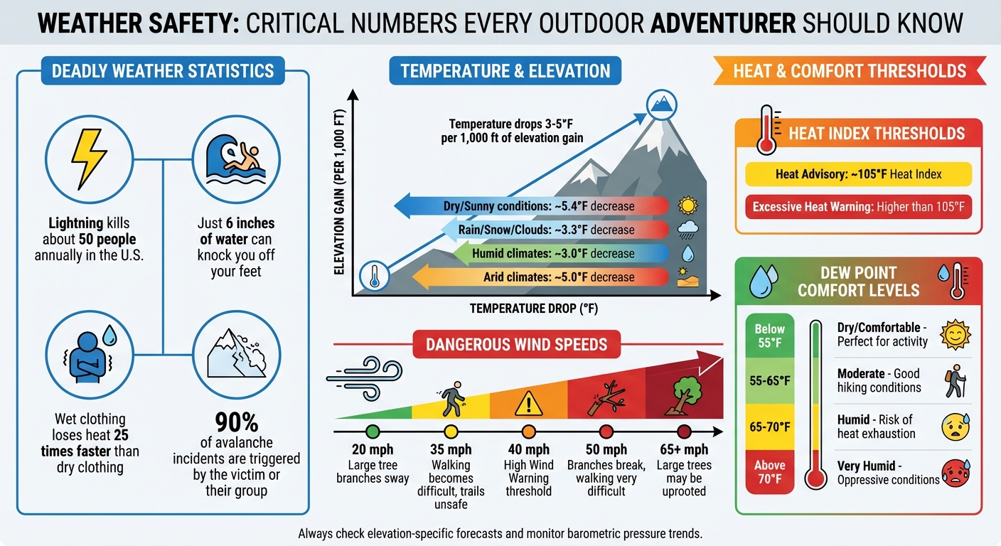
- Lightning kills about 50 people annually in the U.S., and just 6 inches of water can knock you off your feet.
- Temperature drops by 3–5°F per 1,000 ft of elevation gain, making higher altitudes much colder than the base.
- Wind speeds over 35 mph can make trails unsafe, while heavy rain risks flash floods and hypothermia.
To plan for safety:
- Learn key weather terms like dew point, pressure trends, and wind patterns.
- Monitor severe weather alerts (watch, warning, advisory) and adjust plans accordingly.
- Use elevation-specific forecasts to pack the right gear and prepare for sudden changes.
Knowing how to read forecasts and spot warning signs – like falling barometric pressure or descending clouds – can save lives. This guide breaks down weather basics, safety tips, and how to make smarter decisions outdoors.
Essential Weather Safety Statistics and Thresholds for Outdoor Activities
How to Forecast Weather in Wilderness | Survival Skills
sbb-itb-5a98267
Weather Basics: Core Terms and Concepts
To make sense of a weather forecast, it’s essential to grasp the forces behind weather patterns. Factors like temperature, humidity, and atmospheric pressure interact in complex ways to shape the conditions we experience every day. Let’s break down how these elements influence your environment.
Temperature, Humidity, and Atmospheric Pressure
Here’s a simple truth: warmer air holds more moisture than cooler air. That’s why summer often feels sticky, while winter air seems dry. The concept of relative humidity measures how much water vapor is in the air compared to the maximum it could hold at a specific temperature.
The dew point is another key term – it’s the temperature at which air becomes fully saturated with moisture. When the air temperature dips to or below the dew point, water vapor condenses into dew, frost, or even clouds. For outdoor activities, this matters: if the forecasted low temperature is close to the dew point (say, a low of 45°F with a dew point of 48°F), expect heavy condensation on your gear.
Atmospheric pressure plays a major role in weather changes. High pressure causes air to sink and warm, often leading to clear skies. Low pressure, on the other hand, encourages air to rise and cool. As the air cools past the dew point, moisture condenses into clouds and, eventually, precipitation. At sea level, standard atmospheric pressure is about 1,013.25 millibars (mb). Extreme weather events like hurricanes or deep cold snaps can push pressure readings below 980 mb or above 1,040 mb.
Wind is driven by pressure differences. Air naturally moves from high-pressure areas to low-pressure ones, and the greater the difference (often shown on weather maps as tightly packed isobars), the stronger the wind.
| Dew Point (°F) | Comfort Level | Outdoor Impact |
|---|---|---|
| Below 55°F | Dry / Comfortable | Perfect for physical activity; gear stays dry. |
| 55°F – 65°F | Moderate | Slightly humid; good for typical hiking conditions. |
| 65°F – 70°F | Humid | Feels sticky; higher risk of heat exhaustion. |
| Above 70°F | Very Humid | Oppressive; expect condensation and heat-related issues. |
Pay attention to pressure trends when planning outdoor activities. A falling barometer usually signals incoming storms. Similarly, if your altimeter shows a rise in elevation while you’re stationary, it’s a clue that air pressure is dropping – potentially a sign of worsening weather.
These basics set the stage for understanding more dynamic elements like wind patterns and air masses, which directly influence outdoor conditions.
Wind Patterns and Air Masses
An air mass is a large body of air with consistent temperature and moisture levels. Its characteristics depend on its origin: for instance, Continental Polar air masses bring cold, dry weather, while Maritime Tropical air masses deliver warm, humid conditions. When two air masses collide, they form a front – the boundary where significant weather changes often occur.
Cold fronts are like a wedge, forcing warm air upward as they move through. They’re fast-moving and can cause sudden temperature drops – sometimes by dozens of degrees in just minutes. These fronts often bring intense storms, marked by towering cumulonimbus clouds. Warm fronts, in contrast, move more slowly. They typically bring a gradual thickening of clouds (starting with cirrus and progressing to stratus) and steady, prolonged precipitation.
The stability of an air mass also influences weather. Stable air limits vertical movement, resulting in layered clouds, fog, and light, steady rain. Unstable air, however, encourages vertical growth, leading to gusty winds, turbulence, and severe thunderstorms. Puffy cumulus clouds growing into tall thunderheads are a clear sign of instability and a reason to stay alert.
"A front is the boundary between two different air masses… the difference between the two regions can be subtle or dramatic – a strong cold front, for example, can drop temperatures dozens of degrees in a few minutes." – Dennis Mersereau, Reporter
Lastly, wind direction is named for the direction it’s coming from. For example, a “west wind” blows from the west toward the east. On weather maps, tightly packed isobars indicate steep pressure changes and stronger, gustier winds.
Understanding these patterns helps you anticipate weather changes and make smarter decisions for outdoor activities.
Weather Variables to Monitor for Outdoor Planning
When heading outdoors, keeping an eye on specific weather variables can make or break your trip. These factors not only influence your comfort but can also be critical for your safety. From temperature shifts to wind patterns, understanding these elements helps you prepare for whatever nature throws your way.
Temperature and Elevation Changes
The temperature at the trailhead is often misleading when compared to conditions at higher elevations. As you climb, the air expands and cools due to decreasing pressure. Under dry conditions, the temperature drops around 5.4°F per 1,000 feet. When precipitation is involved, the drop is closer to 3.3°F per 1,000 feet.
Take Hawaii’s Mauna Kea as an example. While it might be 85°F at sea level, the summit – standing at 13,803 feet – can plunge to around 10°F, sometimes with snow. Closer to home, imagine starting a hike at 65°F at a 2,000-foot trailhead and climbing to 8,000 feet. That 6,000-foot gain can bring temperatures down to 32°F, even if the start feels balmy. Always pack layers, including a base and insulation, no matter how warm it seems initially.
Also, don’t rely solely on forecasts for nearby towns – they often don’t reflect the microclimates of your specific route. For precise data, use the National Weather Service’s point forecast feature, which provides elevation-specific information.
| Condition | Temperature Change per 1,000 ft |
|---|---|
| Dry/Sunny Weather | ~5.4°F decrease |
| Rain/Snow/Clouds | ~3.3°F decrease |
| Arid Climates | ~5.0°F decrease |
| Humid Climates | ~3.0°F decrease |
These shifts aren’t just numbers – they directly influence your gear choices and decision-making.
Wind Speed and Direction
Wind conditions can escalate dramatically as you gain elevation. According to Ryan Knapp, a meteorologist at the Mt. Washington Observatory:
"As you double wind speed, you quadruple the force (and increase its power eightfold)."
In practical terms, a relatively mild breeze at lower elevations can turn into a fierce, dangerous wind at higher altitudes. Wind speeds are typically measured in miles per hour, but you may also encounter knots (1 knot equals roughly 1.15 mph). Pay attention to tightly packed isobars on weather maps, which signal steep pressure gradients and gusty conditions. Peaks and ridges, in particular, are prone to stronger winds during storms.
Here’s a quick guide to wind impacts:
- 20 mph: Large tree branches sway, and small ripples form on water.
- 35 mph: Walking against the wind becomes tough; large trees begin to bend.
- 50 mph: Branches break, and standing or walking becomes very difficult.
- 65+ mph: Large trees may be uprooted.
Wind direction is equally important. For instance, a cold front often brings northwest winds, while sudden shifts in direction can indicate an approaching storm. Lenticular clouds over mountaintops are another visual cue of strong winds aloft – don’t ignore them.
Precipitation: Probability, Intensity, and Type
Precipitation isn’t just about getting wet – it’s about safety. Wet clothing loses heat 25 times faster than dry clothing, making hypothermia a real threat even in mild temperatures. Heavy rain can also lead to flash floods, especially in slot canyons or near streams. As the NOAA National Weather Service warns:
"It doesn’t have to rain directly over you for there to be flooding. If you notice even a slight rise in water level, seek higher ground immediately!"
Signs of potential flooding include floating debris, water turning muddy, or a sudden roar from upstream. Snow, on the other hand, brings risks like avalanches, which are often triggered by the very people caught in them. Rapid warming or heavy snowfall are red flags for avalanche conditions.
Elevation also influences precipitation. For example, in June 2018, Andrew Skurka observed a stark contrast in weather between Grand Lake, Colorado, and the nearby Continental Divide at 12,000 feet. While Grand Lake’s forecast was mild, the Divide was 15°F cooler with a higher chance of rain and snow – requiring different gear and plans.
Keep an eye on the sky for clues: cirrostratus clouds forming a halo around the sun often signal precipitation within 24 hours, while towering clouds indicate thunderstorms. If cloud bases start descending quickly, it’s a clear sign that conditions are worsening.
Cloud Cover and Visibility
Cloud cover doesn’t just obscure the view – it impacts navigation, safety, and even temperature. Thick clouds can trap heat at night, keeping temperatures warmer, but during the day, they block sunlight and cool things down. Dense, low-level clouds often bring heavy precipitation, while thinner clouds might only result in light drizzle.
Visibility is another critical factor. Dense fog or low clouds can disorient even seasoned hikers, increasing the risk of losing the trail or encountering hazards. In mountainous areas, poor visibility can lead to dangerous missteps or wandering into unsafe terrain. If you notice clouds descending rapidly, it’s a strong signal to consider turning back or finding shelter.
Also, don’t underestimate the sun. UV intensity increases significantly at higher altitudes (above 12,000 feet), so even on overcast days, you’re at risk of sunburn. Always pack sun protection, no matter how cloudy it looks.
Understanding Severe Weather Alerts
Knowing how to interpret severe weather alerts can make all the difference when conditions take a sudden turn. The National Weather Service (NWS) has a tiered alert system designed to keep you safe during unpredictable weather. These alerts are based on detailed meteorological data and can guide your outdoor decisions.
Watches, Warnings, and Advisories
The NWS organizes its alerts into four main categories, each serving a distinct purpose:
- Outlook: Issued 1 to 7 days ahead of time, an Outlook highlights potential hazards in the future. This is your early heads-up to start considering alternative plans.
- Watch: A Watch means conditions are favorable for hazardous weather, but exact timing and location remain uncertain. Usually issued 12 to 48 hours in advance, it’s a signal to stay alert and prepare.
- Warning: A Warning is more urgent – it means hazardous weather is happening or imminent in a specific area. According to the NWS, "A ‘warning’ is issued when hazardous weather poses an immediate threat to life or property". Immediate action is required.
- Advisory: Advisories are less severe than warnings but still signal conditions that could cause inconvenience, such as slick trails or minor snow accumulation. They call for caution rather than drastic action.
Here’s a quick breakdown of these alert types and what they mean for you:
| Alert Type | What It Means | Typical Timing | Recommended Action |
|---|---|---|---|
| Outlook | Potential hazard in the future | 1–7 days ahead | Monitor forecasts and consider alternatives |
| Watch | Hazardous conditions are possible | 12–48 hours ahead | Stay informed and prepare |
| Warning | Hazard is occurring or imminent | Immediate to 36 hours | Take shelter or act immediately |
| Advisory | Weather may cause inconvenience | Ongoing or imminent | Adjust plans and stay cautious |
Understanding these distinctions allows you to incorporate real-time weather updates into your outdoor planning.
For example, a Severe Thunderstorm Warning means storms with winds of 58 mph or higher and hail of at least 1 inch are either happening or detected on radar. The NWS advises: "Severe Thunderstorm Warning: Take Action! Severe weather has been reported by spotters or indicated by radar". If you’re camping, this could mean leaving your tent for sturdier shelter.
Winter weather alerts work similarly. A Winter Storm Warning indicates heavy snow – typically 6 or more inches in 12 hours – while a Winter Weather Advisory covers lighter snowfalls that can still make trails hazardous. A Blizzard Warning, however, signals extreme conditions with sustained winds of 35 mph or higher and visibility reduced to ¼ mile or less for at least 3 hours. Some alerts, like Snow Squall Warnings, are shorter, lasting only 30 to 60 minutes, but warn of intense snow bursts that can cause whiteout conditions.
Heat-related alerts are equally critical. A Heat Advisory is issued when the Heat Index reaches around 105°F, while an Excessive Heat Warning flags even more dangerous conditions.
How to Respond to Severe Weather Alerts
When a Watch is issued, it’s time to review your safety plan. Identify nearby shelters and keep an eye on NOAA Weather Radio or smartphone alerts. For instance, if a Severe Thunderstorm Watch is announced during a backpacking trip, consider shortening your route or planning an early exit.
A Warning demands immediate action. If a Flash Flood Warning is issued near streams or slot canyons, move to higher ground without delay – floodwaters can rise in minutes. Similarly, a High Wind Warning (sustained winds around 40 mph, gusts up to 58 mph) means avoiding ridgelines and wooded areas where falling branches or uprooted trees pose risks. Under a Red Flag Warning – triggered by dry conditions and strong winds – avoid activities that could ignite a fire.
Advisories suggest making adjustments rather than drastic changes. For example, a Dense Fog Advisory means slowing your pace and relying on navigation tools, while a Freeze Warning during the growing season signals the need for extra insulation. Always have a backup plan, including alternative routes, early exit points, and safe spots to wait out sudden changes. The NWS hazards map updates roughly every 5 minutes, so check it frequently to stay informed.
Applying Weather Data to Outdoor Planning
Making sense of weather forecasts is a must for anyone planning outdoor activities. By understanding how weather elements and seasonal changes interact, you can make smarter, safer decisions for your adventures.
Planning for Seasonal Weather Changes
Each season brings its own challenges, and tailoring your plans to these shifts is key. In summer, late-afternoon thunderstorms, high humidity, and heat index values are common. Plan hikes to wrap up before storms typically develop later in the day. Winter, on the other hand, introduces risks like extreme cold, wind chill, and avalanches. It’s sobering to learn that, in 90% of avalanche incidents, the victim or their group triggers the slide. Spring and fall often bring unpredictable conditions, where warm and cold air masses clash, creating the possibility of experiencing "four seasons in one day".
The length of your trip also influences how you use forecasts. For trips under five days, rely on elevation-specific point forecasts for precise gear and route planning. Andrew Skurka, a professional backpacker, highlights the importance of this approach:
"The forecast for the town closest to your route will not necessarily be relevant, so instead I get a ‘point forecast’ by clicking on a more specific location on the embedded map".
For extended trips beyond 10 days, daily forecasts lose reliability. Instead, pack based on climate normals, which offer seasonal averages you can trust.
Humidity patterns also play a major role. Regions east of the 100th Meridian are generally humid, while areas to the west are drier, except during Pacific storm cycles from November to April. This affects how your body handles heat and how much to adjust temperatures for elevation. For example, deduct 3°F per 1,000 feet in humid climates, 4°F in semi-arid areas, and 5°F in arid regions.
By combining these seasonal insights with real-time weather data, you can fine-tune your outdoor plans for better safety and comfort.
Evaluating Multiple Weather Factors Together
When preparing for outdoor activities, it’s not enough to look at weather elements like temperature, wind, or humidity in isolation. These factors combine to shape your actual experience. For instance, a 60°F day with 20 mph winds on an exposed ridge feels much colder than the same temperature in a sheltered valley. Ryan Knapp, a meteorologist at Mt. Washington Observatory, explains:
"As you double wind speed, you quadruple the force (and its increase its power eightfold)".
Start by using the NWS Hourly Weather Forecast to track when conditions might shift – like rain turning to snow or wind speeds peaking. Adjust for elevation using point forecasts since base temperatures often don’t reflect what’s happening at higher altitudes. For heat, combine temperature and humidity to calculate the heat index, as high humidity reduces the body’s ability to cool through sweating. In cold weather, factor in wind chill – remember, wet feet lose heat 25 times faster than dry ones.
Pay attention to barometric pressure trends over 6 to 12 hours. A sharp drop usually signals an incoming cold front and worsening conditions. Cloud behavior is another clue: descending cloud bases often mean the weather is deteriorating, while rising bases suggest improvement.
For a deeper understanding, check the Forecast Discussion section on NWS pages. This provides insights into the meteorologist’s confidence level and the broader weather patterns. Knowing this "big picture" helps you anticipate whether the forecast might change for better or worse.
When these factors combine into dangerous conditions, it’s time to rethink your plans.
When to Postpone or Cancel Outdoor Plans
Some weather conditions are non-negotiable and require canceling or rescheduling your plans. Thunderstorms and lightning are especially dangerous. If you hear thunder, you’re already within striking distance. Alex Anderson-Frey, an atmospheric sciences expert, warns:
"Lightning is still potentially a danger up to half an hour after you hear the last rumble of thunder".
Avoid late-afternoon activities when storms are most likely.
Flash floods are another serious risk. Even if skies above you are clear, rain elsewhere in the watershed can cause dangerous runoff in slot canyons or low-lying areas. Similarly, during Red Flag Warnings or Fire Weather Watches, avoid activities that could spark fires. These conditions combine warm temperatures, low humidity, and strong winds, creating extreme fire danger. High winds above 35 mph make traversing ridges hazardous. Extreme heat is another red flag – reschedule strenuous activities for cooler parts of the day to avoid heat-related illnesses. In winter, heed Warnings or Advisories, and stay alert for avalanche signs like snow cracks, rapid warming, or heavy snowfall.
Set your own safety thresholds for conditions like heat index, wind speed, or cloud development. Continuously monitor cloud bases and barometric pressure, and always have backup routes or safe shelters in mind. As Andrew Skurka wisely points out:
"Knowing the weather will not change the weather, but it may change my decisions, like where I camp and the boldness of my route".
Conclusion
Understanding weather forecasts is one of the most effective ways to stay safe outdoors. It’s not just about knowing the weather; it’s about using that knowledge to make smarter, safer choices. This guide has highlighted how to spot potential hazards by keeping an eye on temperature changes, elevation-specific conditions, and barometric pressure trends. As NOAA wisely puts it:
"The Great Outdoors bring with them various weather and environmental hazards that can ruin your adventure and even be very dangerous. It is important to know your risks, take action to prepare and minimize those risks."
Preparation is everything. Instead of relying solely on general town forecasts, use point forecasts tailored to specific elevations, especially in mountainous areas where conditions can vary drastically. Pay attention to falling barometric pressure, which can signal an incoming storm, and watch for visual signs like towering clouds that often precede thunderstorms. If the weather takes a turn for the worse, don’t hesitate to adjust, postpone, or even cancel your plans.
While you can’t control the weather, you can control how you respond to it. Whether it’s picking a safer campsite, packing the right gear, or rescheduling your trip, these decisions can make all the difference between a fun adventure and a dangerous ordeal. At Adventurism.co, we believe that staying informed is the key to staying safe. Keep an eye on forecasts, stay flexible with your plans, and always put safety first. A little preparation goes a long way in ensuring your outdoor experiences are as safe as they are memorable.
FAQs
How do I quickly adjust a forecast for higher elevations?
To estimate how the temperature changes at higher elevations, you can use the lapse rate. Here’s how it works:
- When there’s no precipitation, the temperature typically drops by about 5.4°F for every 1,000 feet of elevation gain.
- If precipitation is occurring, the decrease is closer to 3.3°F per 1,000 feet.
This method gives you a practical way to predict weather changes as you climb, helping you plan outdoor activities more safely.
What pressure or cloud changes warn me to turn around?
Key indicators to keep an eye on include a sharp decrease in atmospheric pressure, the presence of towering cumulonimbus clouds that hint at unstable weather, or a red sky in the morning – a classic sign of an incoming low-pressure system and possible storms. When you notice these shifts, it’s often a smart move to head back and steer clear of deteriorating conditions.
What weather alert should make me cancel my trip?
Cancel your trip if there are active hurricane or tropical storm warnings, severe weather alerts, or extreme cold and winter storm warnings. These conditions can create dangerous situations and should always be taken seriously.