
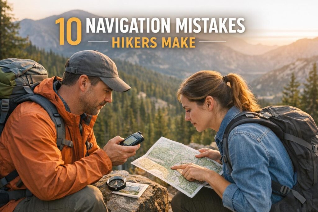
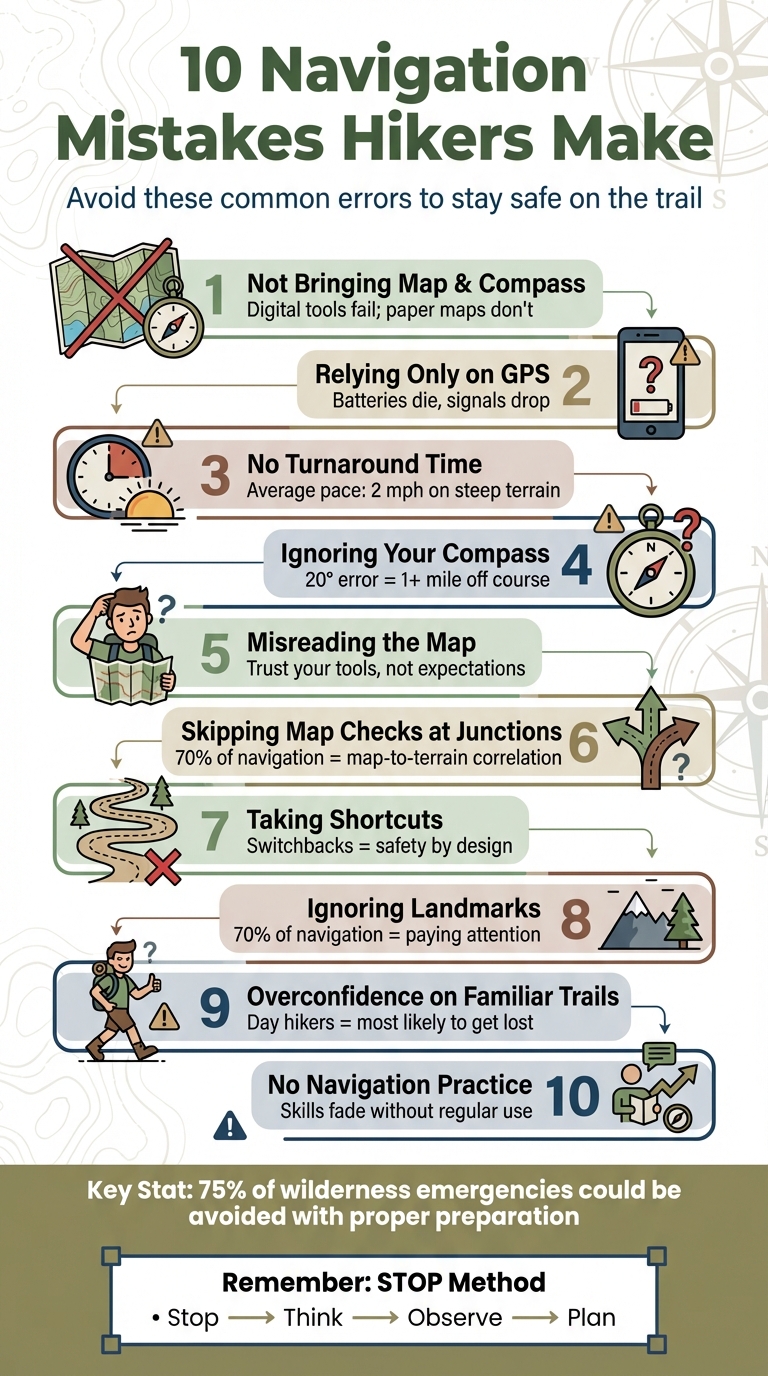
Getting lost while hiking is more common than you think, and it often comes down to avoidable mistakes. From over-relying on technology to skipping basic preparation, these errors can turn a fun outing into a dangerous situation. Here are the top 10 navigation mistakes hikers make and how to avoid them:
- Not bringing a map and compass or knowing how to use them – Digital tools fail; paper maps don’t.
- Relying only on GPS or phone apps – Batteries die, signals drop, and devices break.
- Skipping a turnaround time – Pushing too far can leave you stranded in bad conditions.
- Ignoring your compass – Trust your tools, not your instincts, to avoid walking in circles.
- Misreading the map – Forcing the terrain to match your expectations leads to bigger mistakes.
- Not checking maps at intersections – Trail junctions are common spots to get lost.
- Taking shortcuts – Cutting switchbacks can lead to disorientation and unsafe terrain.
- Failing to notice landmarks – Observing your surroundings is key to staying oriented.
- Overconfidence on familiar trails – Weather and conditions can change what you think you know.
- Skipping navigation practice – Skills fade without regular use, especially under stress.
Key takeaway: Preparation is everything. Bring the right tools, practice navigation skills, and stay alert to avoid getting lost. A few simple habits – like checking maps frequently and setting turnaround times – can make all the difference.
10 Common Navigation Mistakes Hikers Make and How to Avoid Them
5 Ways to NOT Get Lost When Hiking & Backpacking
1. Not Carrying a Map and Compass or Knowing How to Use Them
Relying solely on smartphones or GPS devices during a hike can leave you vulnerable. Batteries die, screens crack, water damages devices, and satellite signals can disappear in dense forests or deep canyons. Even when functioning, GPS units are only accurate within 10 feet about 95% of the time. That remaining 5%? It could place your location up to 500 feet off – a mistake that could have serious consequences.
Take the real-life story of Amanda Eller, for example. In May 2019, she embarked on a short, three-mile hike in Hawaii’s Makawao Forest Reserve without a cell phone, map, or compass. After wandering off the trail, she spent 17 harrowing days lost in the forest, surviving on berries and stream water until a rescue helicopter finally found her.
A paper map and compass, on the other hand, don’t rely on batteries or signals. They offer a broader view of the terrain than a smartphone screen, helping you understand the landscape and plan your route effectively. As Clare Durand, President of Orienteering USA, explains:
"A compass can’t tell you which way to go if you don’t know which way you want to go. It can’t locate you if you get lost. But it can help".
However, these tools are only useful if you know how to use them. Magnetic declination – differences between true north and magnetic north – varies significantly across the U.S., sometimes exceeding 21°. A 15° mistake can lead you more than a mile off course. Before setting out, check the current declination for your area on the NOAA website and adjust your compass accordingly. Many models, like the Suunto MC-2 or Silva Ranger, include built-in adjustment screws for this purpose. Regular practice is key to mastering these adjustments.
Start by practicing map reading and compass navigation in a local park before heading into the wilderness. Keep these essential tools in an easily accessible pocket, not buried in your pack. A basic compass, such as the Suunto A-10, costs around $25, and topographic maps are often even cheaper. This small investment could make all the difference if technology fails and the trail disappears.
2. Depending Only on GPS or Phone Apps Without a Backup Plan
Digital navigation tools like GPS devices and phone apps have made exploring trails easier, but relying on them exclusively can be risky. Batteries drain quickly in cold weather, devices can break if dropped or exposed to water, and satellite signals often disappear in dense forests. These issues can leave you stranded with inaccurate positioning – sometimes off by as much as 10 to 500 feet.
Philip Werner, founder of SectionHiker, emphasizes this point:
"A GPS is not a replacement for a map and compass. If you forget to turn your GPS off and the batteries drain or you lose your satellite connection, you still need to be able to find your way".
Another limitation of digital tools is their display. Phones often show only a small section of the terrain, which makes it harder to plan routes effectively. Similarly, many GPS devices include only basic 100K base maps, which lack the detail necessary for safe navigation in the backcountry. For better accuracy, 24K topographic maps are essential.
To avoid these pitfalls, always carry a paper topographic map and a baseplate compass as backups. Download offline maps before heading out, switch your phone to airplane mode to save battery, and invest in a portable charger and a durable case. Make it a habit to check your location on your physical map every 30 minutes or whenever you reach a trail intersection. These steps not only prepare you for unexpected tech failures but also strengthen your traditional navigation skills, as highlighted in Section 1.
Studies show that 75% of wilderness emergencies could be avoided or minimized with proper preparation and the right gear. By using technology wisely and keeping backups on hand, you can ensure your safety and confidence on the trail.
3. Failing to Set a Turnaround Time or Point
Even seasoned hikers can fall into the trap of "summit fever" – that overwhelming urge to push forward, no matter the risks. Without a clear turnaround time, you risk overextending yourself, running out of daylight, or getting caught in sudden weather changes. What starts as a routine hike can quickly spiral into a survival scenario. Take the Shuei Kato incident as an example: his ordeal was partly due to not having a strict turnaround plan that factored in weather delays. This highlights just how critical it is to set – and stick to – a turnaround time.
A tragic case in Utah in 2011 drives this point home. A hiker fell to his death while attempting to return from "The Wave" after dark. He had missed his safe turnaround point and was navigating dangerous terrain with a faulty flashlight.
The fix? Decide on a firm turnaround time before you even hit the trail. On average, hikers cover about 2 miles per hour on steep or technical terrain. Use this to calculate your pace and pick a time that ensures you’re back well before sunset. If you haven’t reached your goal by that time, turn back – no exceptions. Outdoor expert Claire Ramsdell explains it best:
"Knowing when to quit can be a lifesaving skill, and it’s just as crucial to develop as fitness, navigation skills and other priorities for hiking adventures".
To stay safe, monitor your pace and check your watch at key waypoints to stay on schedule. Be ready to adjust your turnaround time if you hit unexpected challenges like washed-out trails, snow, or incoming storms. And here’s another critical tip: if you’ve already used more than half your water or food before reaching the halfway point, it’s time to head back. Think of a turnaround plan as another essential safety tool, just like a map or compass.
Seth Thomas, a personal trainer and former hiking guide, underscores the importance of this practice:
"Knowing when to turn around is just lifesaving. We all think it’s never going to happen to us, but people do lose their lives up on the mountain".
Setting a turnaround time doesn’t limit your adventure – it ensures you can enjoy many more hikes in the future.
4. Walking in Circles Because You Don’t Trust Your Compass
When your gut feeling clashes with what your compass is telling you, you might find yourself unintentionally walking in circles. This phenomenon, often called "bending the map," happens when you try to force your surroundings to match where you believe you should be, rather than trusting the compass to guide you correctly.
This issue becomes even more pronounced in challenging conditions like fog, whiteouts, or darkness. With no clear landmarks in sight, it’s tempting to rely on your internal sense of direction, which feels more trustworthy than a compass pointing in what seems like the "wrong" direction. But even a small error – just 20 degrees – can lead you more than a mile off course or cost you hours trying to retrace your steps. As the American Hiking Society warns, panicking and running around to find the trail often "only leads you further from the trail than you are and causes more disorientation and frustration".
The first step to solving this is understanding why your compass might seem inaccurate. Magnetic north isn’t the same everywhere – it can vary by over 21 degrees depending on your location, such as between the Great Smoky Mountains and the Pacific Northwest. Before heading out, adjust for magnetic declination using NOAA’s magnetic calculator. Also, be cautious about keeping your compass near metal objects like belt buckles or car hoods, as these can interfere with the needle and cause incorrect readings.
Building confidence in your compass takes practice. Try night navigation exercises on familiar trails to get comfortable relying on it without visual aids. Master techniques like "boxing the needle", which involves aligning the red magnetic needle within the orienting arrow until it becomes second nature. And when doubt creeps in, remember the STOP method: Stop, Think, Observe, and Plan. John Godino from the Columbia River Orienteering Club puts it best: "When that little voice starts to talk, it’s time to pause and reassess".
5. Making the Map Match What You Want to See
Relying too much on technology can lead you astray, but misreading your map can be just as problematic. When you’re convinced you’re on the right path, it’s easy to start interpreting map details in a way that fits what you want to see, rather than what’s actually there. This mental trap, often called "bending the map", happens when you ignore physical evidence and force your surroundings to align with your expectations. For example, you might convince yourself that a random ridge is the one you’re looking for or that a dry creek bed is the trail you need. Why? Because admitting you’re off-course can feel unsettling. Unfortunately, this habit not only wastes time but also increases the risk of getting seriously lost, opening the door to more navigation errors.
Misreading terrain features is one of the biggest dangers in backcountry navigation. Corey Buhay from Gaia GPS highlights this issue:
"Most lost hikers get into further trouble by pushing ahead when they start to feel uncertain rather than cutting their losses and turning back".
This urge to press forward, even when things don’t add up, often turns a small mistake into a much bigger problem.
Even tools like GPS devices, which are designed to help, can sometimes lead you astray if you rely on them too heavily. Philip Werner, founder of SectionHiker, points out:
"Your GPS position can be off by 10 feet or off by 500 feet. For example, your GPS might say you’re standing on a trail when it’s obvious that you’re not".
A real-world example of this comes from a hiker known as "DLT", who got lost during a rainy night hike from Crabtree Meadows to Mt. Whitney. Although their GPS showed they were on the trail, they couldn’t find any trace of it on the ground. Eventually, they realized the trail was actually 30 feet above them, perched on a steep rock face.
So, how do you avoid these pitfalls? It starts with humility. Trust your tools over your instincts. If the terrain doesn’t match what you expect – like encountering an unexpected cliff, river, or steep climb – stop immediately. Corey Buhay offers this advice:
"If you come across terrain you don’t expect – like a raging water crossing or some surprise fourth-class climbing – turn around. It either means you’re off-route, or you’re unprepared for the terrain".
To stay on track, check your map at every trail junction or major landmark. Practice matching real-world features like peaks, valleys, and ridges to the contour lines on your map. And when doubt creeps in, take a moment to pause. Sit down, have a snack, and reorient yourself. Those few minutes of recalibration can save you hours of wandering in the wrong direction.
sbb-itb-5a98267
6. Not Checking Your Map at Trail Intersections
Trail intersections are one of the most common places where hikers lose their way. It’s surprisingly easy to confuse a game trail or a drainage path with the main route. Many hikers skip checking their map at these junctions, assuming the correct path will be obvious. This small oversight can lead to hours of unnecessary hiking – or worse, a dangerous situation. Making it a habit to pause and check your map at every intersection is a simple yet crucial step for staying on track.
Research highlights that 70% of effective navigation relies on consistently aligning your map with the terrain. Matthew Denis, a former contributor to Digital Trends, emphasizes this point:
"Establishing the habit of keeping track of where you are at all times means regularly correlating what you see on the map with what you see on the ground".
The solution? Always reference your map when you reach a trail junction. As you do, identify one or two landmarks that should appear along the way. Another helpful trick is to briefly turn around and view the intersection from the opposite direction – it often looks different from behind. If those landmarks don’t show up within a reasonable distance (typically about 2 miles per hour of hiking pace), stop and reassess. Greg Rodgers offers a key piece of advice:
"The best way to avoid bending the map is to check it frequently to make sure you know where you are before you get too far from your intended route".
Another helpful habit is to record the time when you pass each junction. This makes it easier to backtrack if needed and helps you monitor your pace. If you find yourself at a junction that doesn’t match your map, take a moment to use the S.T.O.P. method – Stop, Think, Observe, Plan – before moving forward. Spending just a few minutes recalibrating can prevent a minor mistake from escalating into a serious issue.
7. Taking Shortcuts and Cutting Across Switchbacks
Switchbacks are carefully designed to keep trail slopes manageable, typically between 15–20°. These zigzagging paths might seem like a longer route, but they’re there for a reason: safety. Cutting across them not only undermines this design but also increases risks for hikers. Despite this, many hikers are tempted to take shortcuts, thinking it will save time. The truth? It often leads to disorientation and dangerous terrain.
On a topographic map, switchbacks look like distinct "Z" shapes. When you cut across them, you erase these recognizable patterns, making it harder to pinpoint your location. Worse, these shortcuts create informal trails that can mislead others. Max DesMarais, Founder of My Outdoor Basecamp, highlights the broader impact:
"Creating a shortcut by hiking straight up and skipping the zigs and zags of a switchback is detrimental to the soil and local vegetation. By creating a straight path, you aren’t just breaking trail etiquette, you’re creating more avenues for erosion".
Straying from marked trails doesn’t just affect navigation – it damages the trail itself. These shortcuts undermine the integrity of the path, disrupt trail etiquette, and introduce safety hazards. Switchbacks are specifically engineered to avoid steep or unstable terrain, so bypassing them could lead you directly into danger. If you get injured or lost on an unofficial path, rescue teams may not even know where to search.
Switchbacks also include flat sections, called "landings", which have gentle slopes of 0–5%. These spots are perfect for resting or letting others pass safely. To avoid accidentally wandering onto an unofficial trail, keep an eye out for sticks arranged in an "X" on the ground – this universal sign means the path is not part of the marked trail and should be avoided.
When navigating tight switchback corners, remember that hikers going uphill have the right of way. Trekking poles can also be a great tool for maintaining balance, especially if you’re carrying a heavy pack. While cutting straight up might seem like a shortcut, it’s actually more exhausting and far less efficient than sticking to the gradual incline of a well-designed switchback.
8. Not Paying Attention to Landmarks and Sun Direction
While GPS can guide you, your brain naturally builds a mental map of your surroundings. However, many hikers fail to fully engage this ability, often following the trail passively until something goes wrong – like the path disappearing or a wrong turn throwing them off track.
Cam Honan, a seasoned hiker and author, emphasizes this point:
"The key to being a proficient navigator is paying attention. Indeed, I would estimate that 70% of navigational proficiency comes down to this one simple point."
Unfortunately, many hikers treat the environment as mere scenery, only noticing it when they’re already in trouble. Developing strong observational skills is just as important as using technical navigation tools.
This lack of attention can become especially risky during descents. For example, there’s a well-documented case of a hiker who lost sight of key landmarks on their way down, leading to a prolonged emergency. Landmarks like ridges and gullies often appear to converge on the way up but can diverge significantly on the way down, making it easy to get disoriented if you’re not actively observing your surroundings. This is why sharpening your natural ability to notice and remember landmarks is as essential as relying on any digital device.
To improve your navigation, try time-stamping key landmarks as you pass them. Since hikers typically cover about 2 miles per hour on average terrain, this habit can help you estimate distance and pace if you need to retrace your steps. Natural features such as creeks and ridgelines, along with the sun’s position, can also serve as reliable navigation aids. For instance, in the Northern Hemisphere, the sun is due south at midday . You can even use the shadow compass method: place a stick upright in the ground, mark the shadow’s tip, wait 20 minutes, and mark the new tip. The line between these two points will run roughly East-West.
If you find that landmarks don’t align with your map, use the S.T.O.P. method: Stop, Think, Observe, and Plan. Paying attention isn’t just about avoiding mistakes – it’s about staying oriented and confident throughout your hike.
9. Being Too Confident on Trails You Know
Familiarity with a trail can sometimes create a false sense of security. When you’ve hiked the same path multiple times, it might feel unnecessary to bring a map or compass. After all, you "know" the route, right? But this kind of overconfidence is exactly what can lead to trouble. In fact, day hikers – often relying on their memory – are statistically the most likely group to get lost and require search and rescue assistance. And let’s not forget how quickly unpredictable weather can turn even the most familiar trail into a confusing maze.
Changing environmental conditions can make a well-known trail feel completely foreign. The American Hiking Society puts it plainly:
"Even if you know this trail like the back of your hand, snow, fog and darkness may obscure familiar features".
This highlights how weather and visibility can erase the landmarks you rely on, making the trail harder to navigate.
Another issue with overconfidence is the challenge of retracing your steps. Trails often look very different when you’re heading back, and features that seemed obvious on the way out might not stand out on the return trip. Many hikers overlook the importance of taking note of how the trail appears from both directions, which can lead to disorientation.
Overconfidence can also lead to a mental pitfall called "bending the map." This happens when hikers ignore evidence that contradicts their expectations, such as an unexpected stream or fork in the trail, because they’re so certain they’re on the right path. Travel writer Greg Rodgers explains:
"Your memory may not be as good as you think, especially while your nerves get the best of you if you think you’ve veered off course".
Even on trails you think you know inside and out, always carry a map and compass. Take time to confirm your route at every junction, and set a firm turnaround time to avoid the dangers of hiking too late in the day.
10. Skipping Navigation Practice Before Your Hike
Knowing how to use a map and compass is one thing; being able to rely on those skills under pressure is another. Many hikers assume they’ll figure it out when the time comes, but that’s a dangerous bet. As Adventure Wiser puts it:
"Using a compass and map shouldn’t be your first move when you’re lost and freezing – it’s like reading parachute instructions after you’ve jumped".
Navigation skills aren’t something you can just wing when you’re cold, tired, or racing against the setting sun. Without regular practice, those skills can fade, leaving you scrambling to recall critical details when it matters most. Instead, your brain should be able to rely on well-practiced habits.
Here’s the key: about 70% of effective navigation comes from staying aware of your surroundings and consistently matching what you see on your map to the terrain around you. To sharpen your skills, start small. Head to a local park or familiar trail and try navigating without your phone. Turn on airplane mode and use only a paper map and compass for an hour.
Challenge yourself with exercises like dead reckoning – pick a point on your map, take a bearing, and walk straight to it without shortcuts. Push further by practicing at dusk, trusting your compass when landmarks are harder to spot. These drills aren’t just exercises – they’re what build the muscle memory that could save your life.
Conclusion
Getting lost on a trail often comes down to a lack of preparation and practice. The difference between a smooth hike and needing rescue can hinge on a few straightforward habits: reviewing your route ahead of time, bringing a map and compass (and knowing how to use them), setting a clear turnaround time, and staying mindful of your surroundings.
To sharpen your skills, start small. Try navigating a local park using just a paper map and compass. As mentioned earlier, stop at every trail intersection to check your map, get familiar with your hiking pace across different terrains to estimate distances, and always have backup tools in case your GPS fails. The key to effective navigation? Regularly aligning your map with the landscape around you.
Navigation is all about catching small mistakes before they become big problems. If you find yourself unsure of your location, use the STOP method: Stop, Think, Observe, Plan. As the legendary frontiersman Daniel Boone once quipped:
"I have never been lost, but I will admit to being confused for several weeks".
Fortunately, you don’t have to let confusion last that long. Every moment spent preparing and practicing builds confidence and keeps you safer on the trail.
Whether you’re gearing up for your first backcountry adventure or fine-tuning skills you’ve relied on for years, check out Adventurism.co for more outdoor tips. The wilderness is calling – navigate with care.
FAQs
What’s the best way to practice using a map and compass before a hike?
Practicing with a map and compass before hitting the trail is a smart way to boost your confidence in navigating. Start by getting to know the basics of your compass. Understand key parts like the baseplate, the rotating housing, and the magnetic needle. Don’t forget to learn how to adjust for local declination – this helps align your compass with true north.
Once you’ve got the basics down, try some simple exercises. Begin by orienting a map to match the landscape around you, then practice taking a bearing to a visible landmark. You can do these drills in your backyard, at a nearby park, or on a short, familiar trail. As you grow more comfortable, challenge yourself by practicing in different conditions, like low light or varying weather. This will better prepare you for real-world hiking situations. Repeating these steps will build muscle memory, making it easier to stay on course and avoid getting lost during your adventures.
What should I do if my GPS stops working while hiking?
If your GPS stops working, don’t panic – stay composed and turn to your backup tools. Always have a topographic map and compass with you, and make sure you know how to use them before venturing out. A compass can help confirm your direction, while the map can guide you by identifying landmarks like streams, ridges, or trail markers to help you regain your bearings.
Pause where you are and retrace your steps to the last spot where you were confident of your location. If you’re on a marked trail, keep an eye out for blazes, cairns, or intersections that can help guide you. If you still can’t find your way, stay put in a safe area. Make yourself noticeable by wearing bright clothing or using a whistle, and conserve your energy. If you have cell service, call for help and provide details like your last known location and any nearby landmarks. For areas without cell coverage, a personal locator beacon or satellite messenger can be a lifesaver.
To prevent similar situations in the future, always have a backup plan. Download offline maps, carry extra batteries or a power bank, and practice using a map and compass in familiar settings. These precautions will prepare you for moments when technology lets you down.
Why is it important to set a turnaround time when hiking?
Setting a turnaround time is a smart way to stay safe while hiking. It ensures you make it back before nightfall, avoid worsening weather, and conserve your energy, food, and water. This straightforward precaution can help prevent accidents and reduce the chances of needing emergency help.
By deciding on a turnaround time ahead of your hike – and sticking to it – you can focus on enjoying the trail without exposing yourself to unnecessary risks.